

DJI Zenmuse L2 vs L3: Which LiDAR System Is Right for You?
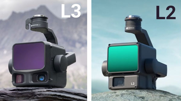
DJI Zenmuse L2 and L3 are integrated airborne LiDAR systems for surveying, mapping, forestry and infrastructure projects. The L2 remains relevant for operators using compatible Matrice aircraft, while the L3 offers longer detection range, more returns and dual high-resolution RGB cameras on the Matrice 400 platform.
This guide compares the specifications and explains where each system fits into a professional mapping workflow.
DJI Zenmuse L2 vs L3: specification comparison
| Specification | Zenmuse L2 | Zenmuse L3 |
|---|---|---|
| LiDAR wavelength | 905 nm | 1535 nm |
| Detection range at 10% reflectivity / 100 klx | 250 m | Up to 950 m at 100 kHz |
| Maximum returns | 5 | Up to 16 (at specified pulse rates) |
| System accuracy (DJI test conditions) | 4 cm vertical / 5 cm horizontal at 150 m | 3 cm vertical / 4 cm horizontal at 120 m |
| RGB cameras | One 20 MP 4/3 CMOS camera | Two 100 MP 4/3 CMOS cameras |
| Combined RGB horizontal field of view | Approx. 73.7° | 107° |
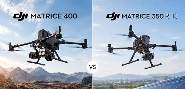
| Compatible aircraft | Matrice 300 RTK (with RC Plus), Matrice 350 RTK and Matrice 400, subject to current DJI compatibility requirements | Matrice 400 with dedicated L3 connector |
| Indicative single-flight mapping coverage | Up to 2.5 km² | Up to 10 km² at 300 m, under DJI test conditions |
All quoted performance figures refer to specific DJI test conditions, not guaranteed results. Reflectivity, weather, terrain, vegetation, flight altitude, flight speed and processing methods affect actual results. Always follow local flight regulations.
1. LiDAR range and mapping productivity
The Zenmuse L2 has a specified 250 m detection range at 10% target reflectivity under 100 klx illumination. Under different conditions, DJI specifies up to 450 m for a 50% reflective target at 0 klx. The DJI Zenmuse L3 reaches up to 950 m at 10% reflectivity and 100 klx at its specified 100 kHz setting.
Longer detection range may permit higher-altitude acquisition where legally and operationally appropriate. DJI quotes up to 2.5 km² per flight for L2 and up to 10 km² for L3 with the DJI Matrice 400 at 300 m under specified conditions. These are not like-for-like guarantees for every survey.
2. Accuracy at different flight heights
DJI specifies L2 system accuracy of 4 cm vertical and 5 cm horizontal at 150 m. For L3, DJI specifies 3 cm vertical and 4 cm horizontal at 120 m, and 5 cm vertical and 7.5 cm horizontal at 300 m. Compare the test conditions, required deliverables and your own control-point verification rather than relying on a single headline figure.
3. Vegetation and multiple returns
L2 supports up to five returns; L3 supports up to sixteen at specified pulse rates. Multiple returns can improve the information collected from layered vegetation, where a pulse may interact with branches, leaves and surfaces below the canopy. Actual ground-point density still depends on canopy structure, flight planning and processing.
4. RGB mapping cameras
L2 integrates one 20 MP 4/3 CMOS camera. L3 adds two 100 MP 4/3 CMOS cameras with a combined 107° horizontal field of view. These support workflows that need both LiDAR and high-resolution RGB imagery, including coloured point clouds, orthophotos and 3D reconstruction.
5. Aircraft compatibility and upgrade planning
Compatibility is a major purchasing consideration. L2 supports the DJI Matrice 350 RTK, Matrice 300 RTK with the required controller, and Matrice 400 subject to DJI's current compatibility requirements. L3 requires the DJI Matrice 400 and its dedicated connector. An existing M350 operator cannot treat L3 as a simple payload-only upgrade.
Which system fits your project?
When L2 makes sense
- You already operate a compatible Matrice 300 RTK or Matrice 350 RTK.
- Your project size and flight altitude fit within L2's practical productivity.
- You do not need L3's additional range, return capability or RGB resolution.
When L3 makes sense
- You operate or plan to invest in Matrice 400.
- You regularly survey large areas, long corridors or complex vegetation.
- Higher acquisition efficiency and high-resolution RGB data are important to your workflow.
Frequently asked questions
Can Zenmuse L3 be installed on Matrice 350 RTK?
No. L3 is designed for Matrice 400 and requires its dedicated connector.
Does L3 always produce more ground points in forests?
No result is guaranteed. Its multiple-return capabilities and laser characteristics can help, but canopy conditions, flight settings and processing are decisive.
Does a longer LiDAR range mean I can fly at any altitude?
No. Mission planning must comply with applicable aviation rules, airspace restrictions and operational approvals.
Configure your DJI LiDAR solution
KopterWorx supplies professional DJI Enterprise systems and can help match aircraft, payload and workflow to your survey requirements. Explore Zenmuse L3, Matrice 350 RTK and Matrice 400, or contact us about your project.
Slovenska različica: DJI Zenmuse L2 proti L3
DJI Zenmuse L2 in L3 sta integrirana zračna LiDAR sistema za geodezijo, kartiranje, gozdarstvo in infrastrukturne projekte. L2 ostaja uporaben za lastnike združljivih dronov Matrice, L3 pa na platformi Matrice 400 ponuja daljši doseg, več odbojev in dve visokoločljivi RGB kameri.
Primerjava specifikacij
| Lastnost | Zenmuse L2 | Zenmuse L3 |
|---|---|---|
| Valovna dolžina | 905 nm | 1535 nm |
| Doseg pri 10 % odbojnosti / 100 klx | 250 m | Do 950 m pri 100 kHz |
| Največje število odbojev | 5 | Do 16 pri določenih frekvencah |
| Sistemska natančnost (testni pogoji DJI) | 4 cm vertikalno / 5 cm horizontalno pri 150 m | 3 cm vertikalno / 4 cm horizontalno pri 120 m |
| RGB kamere | Ena kamera 20 MP, 4/3 CMOS | Dve kameri 100 MP, 4/3 CMOS |
| Skupno horizontalno vidno polje RGB | Približno 73,7° | 107° |
| Združljivi droni | Matrice 300 RTK (z RC Plus), Matrice 350 RTK in Matrice 400 ob upoštevanju trenutnih zahtev DJI | Matrice 400 z namenskim priključkom L3 |
| Okvirna pokritost v enem letu | Do 2,5 km² | Do 10 km² pri 300 m v testnih pogojih DJI |
Navedene zmogljivosti veljajo za določene testne pogoje DJI. Dejanski rezultati so odvisni od odbojnosti, vremena, terena, vegetacije, višine in hitrosti leta ter obdelave podatkov. Upoštevajte veljavne letalske predpise.
1. Doseg LiDAR in učinkovitost kartiranja
Zenmuse L2 pri 10-odstotni odbojnosti in osvetlitvi 100 klx doseže 250 m. Pri 50-odstotni odbojnosti in 0 klx DJI navaja do 450 m. DJI Zenmuse L3 pri 10-odstotni odbojnosti in 100 klx pri frekvenci 100 kHz doseže do 950 m.
Večji doseg lahko omogoči zajem z večje višine, kadar to dovoljujejo predpisi in razmere. DJI za L2 navaja do 2,5 km² na let, za L3 na DJI Matrice 400 pa do 10 km² pri 300 m v določenih testnih pogojih. Ti številki nista zagotovljena rezultata vsakega projekta.
2. Natančnost pri različnih višinah
DJI za L2 pri 150 m navaja sistemsko natančnost 4 cm vertikalno in 5 cm horizontalno. Za L3 pri 120 m navaja 3 cm vertikalno in 4 cm horizontalno, pri 300 m pa 5 cm vertikalno in 7,5 cm horizontalno. Pri izbiri upoštevajte testne pogoje, zahtevane končne izdelke in preverjanje s kontrolnimi točkami.
3. Vegetacija in več odbojev
L2 podpira do pet odbojev, L3 pa do šestnajst pri določenih frekvencah. Več odbojev lahko pomaga pri zajemu več plasti vegetacije, vendar je dejanska gostota talnih točk odvisna tudi od krošenj, načrtovanja leta in obdelave podatkov.
4. RGB kamere za kartiranje
L2 ima eno 20 MP kamero s tipalom 4/3 CMOS. L3 uporablja dve 100 MP kameri s skupnim horizontalnim vidnim poljem 107°. Kombinacija LiDAR in visokoločljivih RGB podatkov je uporabna za barvne oblake točk, ortofoto posnetke in 3D rekonstrukcije.
5. Združljivost in načrtovanje nadgradnje
Združljivost je pomembna pri nakupu. L2 podpira DJI Matrice 350 RTK, Matrice 300 RTK z zahtevanim krmilnikom in Matrice 400 ob upoštevanju aktualnih zahtev DJI. L3 zahteva DJI Matrice 400 in namenski priključek. Lastnik M350 zato L3 ne more uporabiti kot preprosto zamenjavo tovora.
Kateri sistem je primeren za vaš projekt?
Kdaj je smiselna izbira L2?
- Že uporabljate združljiv Matrice 300 RTK ali Matrice 350 RTK.
- Velikost projektov in višine zajema ustrezajo zmogljivostim L2.
- Ne potrebujete dodatnega dosega, odbojev ali RGB ločljivosti L3.
Kdaj je smiselna izbira L3?
- Uporabljate ali načrtujete nakup Matrice 400.
- Redno kartirate velike površine, dolge koridorje ali zahtevno vegetacijo.
- Pomembna sta učinkovitost zajema in visokoločljiv RGB posnetek.
Pogosta vprašanja
Ali lahko Zenmuse L3 namestim na Matrice 350 RTK?
Ne. L3 je namenjen Matrice 400 in zahteva namenski priključek.
Ali L3 v gozdu vedno zajame več talnih točk?
Ne nujno. Več odbojev in značilnosti laserja lahko pomagajo, vendar so odločilni tudi gostota krošenj, parametri leta in obdelava.
Ali daljši doseg pomeni, da lahko letim na poljubni višini?
Ne. Višina in način izvedbe morata biti skladna z letalskimi predpisi, omejitvami zračnega prostora in ustreznimi dovoljenji.
Sestavite svojo DJI LiDAR rešitev
KopterWorx dobavlja profesionalne sisteme DJI Enterprise in pomaga pri izbiri drona, tovora in delovnega postopka. Oglejte si Zenmuse L3, Matrice 350 RTK in Matrice 400 ali nas kontaktirajte glede svojega projekta.
Powered by Mirasvit Magento 2 Extensions
-
 DJI Matrice 400 vs Matrice 350 RTK – Complete Comparison
- DJI Zenmuse L2 vs L3: Which LiDAR System Is Right for You?
-
 DJI AP100 Parachute for Matrice 400 – C5/C6 Compliance, Safety and Full Overview
-
 Najboljši DJI dron 2026 – Kateri izbrati?
-
 Best DJI Drone 2026 Comparison – Neo 2, Avata 2, Mini 5 Pro, Air 3S, Mavic 4 Pro