DJI GS PRO Enterprise
DJI GS Pro is an iPad app designed to control or plan automatic flights for DJI aircraft. Through its clear, concise interface, complex flight missions can be planned with a few taps. GS Pro will then automatically take pictures at pre-set waypoints, providing the accuracy required for precision mapping. A Virtual Fence feature increases safety and ease of use by locking the aircraft’s height and speed within a designated area. With these features, GS Pro dramatically increases the efficiency of various industrial applications, including but not limited to, aerial imaging, architecture, precision agriculture, electrical inspections, search and rescue, safety control. DJI GS Pro Enterprise, can conduct automated flight missions, manage flight data on the cloud, and collaborate across projects to efficiently run your drone program.
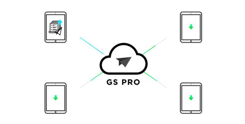
Flight Data Management - Cloud Service
Back up flight data securely on the cloud, giving missions higher reliability and accuracy. Reference historical information on flight missions, aircraft, members, and flight logs so that workflows can be optimized.
Flight mission data is visible to all members of a project team, making data sharing easier. Members can view edits made by other team members or duplicate flight parameter settings for new missions.
FLEE AND PILOT MANAGEMENT
Manage pilots and drones through the creation of teams, making missions more coordinated. Designate roles with different permissions to improve communication. Track the status of aircraft to make proactive purchasing and maintenance decisions.
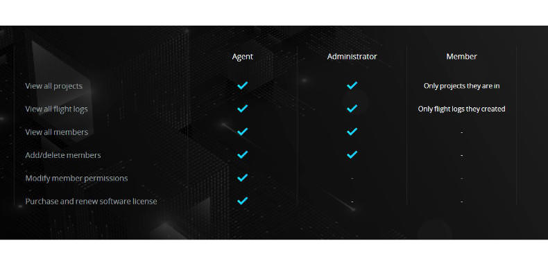
PROJECT MANAGEMENT
Improve the efficiency of your drone operations by tracking individual projects and streamlining the project management process. Access to project status can be granted on a per-project basis so that critical data is only available to the relevant members.
| Project Management | Operator | |
| Manage personal flight missions | ✔ | ✔ |
| View flight missions of other members | ✔ | ✔ |
| Copy mission settings of other members | ✔ | ✔ |
| Archive and unarchive projects | ✔ | |
| Manage project members | ✔ | |
| View the mission's flight activities | ✔ | |
| Set flight parameters from a particular mission as default settings | ✔ |
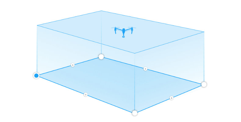
3D - MAP AREA
Create replicable, automated flight plans for 3D mapping missions. After selecting an area, GS Pro automatically generates efficient flight paths after the user set their required flight zone and camera parameters. The aircraft will then follow this route throughout its mission. The image data captured during these flights can be input into 3D reconstruction software to generate the 3D map, while the mission itself can be saved for re-use.
Adjust parameters including photo overlap ratio, altitude angle - parallel or vertical to the main flight path - course angle, and margin. Capture images at equal time intervals, equal distance intervals, or to hover at a waypoint during capture.
.jpg)
To achieve better 3D reconstruction, the overlapping photo is optimised for a range of supported cameras. It can also be independently adjusted. Two Flight Course Modes are available: Inside Mode, in which the aircraft follows an automatically generated routed within the chosen area, and Scan Mode which provides the fastest route to cover a designated area.
3D MAP POI
Generate detailed maps of tall structures using 3D Map POI. Simply choose the subject and set a distance between it and the aircraft. GS Pro will then provide relevant parameters including speed and time required to circuit the structure.
AUTOMATED FLIGHT MISSION - WAYPOINTS
Set a waypoint flight path, define waypoint actions, then start flying with a tap. Up to 99 waypoints are available, depending on the needs of each flight. Each waypoint can have p to 15 consecutive actions, including aircraft rotation, gimbal pitch, start/stop recording, photo capture, and hover. After the aircraft finishes its flight mission, it can be set to return to home, hover, or land
VIRTUAL FENCE
Virtual fence defines a specific area of flight and is useful in scenarios where some areas of a site are no-fly zones or if flight should only happen within one area, such as during manual pesticide spraying or flight. It is also useful in pilot training situations. As the aircraft approaches the virtual fence, it will stop and hover to ensure it stays within the flight area.
The size and shape of the Virtual Fence are completely customisable. It can be created pre-flight, or fly around the zone to mark boundaries using the aircraft's GPS coordinates.
PHOTOMAP
The Photomap function helps users efficiently create aerial photograph-based maps. After users complete an aerial photography mission in the desired area and import the photos into GS Pro, the software will automatically create a composite photo of the area that users can adjust as needed.
COMPATIBILITY
GS Pro is compatible with the following DJI aerial platforms and flight controllers:
Phantom 3 Standard/4K/Advanced/Professional,
Phantom 4/Pro/Advanced, Phantom 4 Pro V2,
Inspire 1/Inspire 2
Matrice 100/600/600 Pro,
Matrice 200/210/210 RTK , A3, N3
Compatible cameras:
Phantom 3 Standard/4K/Advanced/Professional,
Phantom 4/Pro, and
Zenmuse X3, X5, X5R, X4S, X5S, Z3, Z30, and XT
FLIGHT DATA MANAGEMENT
Back up flight data securely on the cloud, giving missions higher reliability and accuracy. Reference historical information on flight missions, aircraft, members, and flight logs so that workflows can be optimized. Flight mission data is visible to all members of a project team, making data sharing easier. Members can view edits made by other team members or duplicate flight parameter settings for new missions.
FLEET AND PILOT MANAGEMENT
Manage pilots and drones through the creation of teams, making missions more coordinated. Designate roles with different permissions to improve communication. Track the status of aircraft to make proactive purchasing and maintenance decisions.